The White Mountains of New Hampshire are home to some of the best hikes in New England. From the top of Mt. Washington to a stroll through Lincoln Woods, there are hundreds of miles of hiking trails of various difficulties and lengths. Scott has put together a few of the local favorites for you to enjoy on your next visit to the resort.
Easy Hikes
Discovery Loop Trail
The discovery trail is a loop (actually, figure of eight, as it’s two loops) that offers an easy self-guided nature walk. The right-hand loop descends gradually to cross a pleasant stream on a bridge, while the longer, left hand loop ascends by switchbacks. This branch of the trail offers limited views of Mount Osceola, the highest mountain south of the Kancamagus Highway, as well as Scar Ridge.
The entire trail is about a mile and a half, with excellent footing and less than 200 feet of elevation gain.
To get there: Take a left out of the parking lot and drive left (east) on Route 112 approximately four miles. Parking lot GPS coordinates are: N44° 02.777 | W071° 33.398 (elevation - 1,504')
Difficulty: Easy
Scenery: C
Driving Time: 5-10 minutes
Distance: 1.4 miles round trip
Elevation Gain: >200 feet
Elephant Head
Elephant’s Head is a very short hike in the heart of beautiful Crawford Notch. The hike begins on the Webster Jackson Trail, across from the train tracks in Crawford Notch (not to be confused with the Crawford Path). Follow the Webster Jackson Trail uphill 150 yards to a junction. At the junction, take a right onto the Elephant’s Head spur trail. The trail crosses a stream on some log beams and goes uphill for a short distance before leveling out. There’s one last climb to reach the top of the ledge. Caution should be taken on top of Elephant’s Head, as there is a serious drop to the Notch below. The hike offers a tremendous view for very little effort.
To get there: Take a right out of the parking lot (onto Route 112/Main St) and follow until you reach I-93. Take a right onto I-93 north and follow until exit 35. Off of exit 35, go straight, following Route 3 north until you reach Route 302 (approximately 10 miles). At the junction, turn right onto Route 302 east for about 8.5 miles, or about a quarter mile beyond the AMC Highland Center. The trail begins on the opposite side of the road, and the Elephant’s Head formation is clearly visible from Route 302.
Difficulty: Very Easy
Scenery: B
Driving Time: 45 minutes
Distance: .6 miles round tripElevation Gain: >200 feet
Sabbaday Falls
Enjoy a short trip to a beautiful waterfall. It’s perfect in the spring when the water is high, or during fall foliage. The trail leaves from the Sabbaday Falls picnic area on the south (right) side of Route 112. The path is graded gravel, wide and very easy. It follows the river and there is a small climb at the end. When you reach the junction, take the left-hand path to walk along the falls. There is a pool, a small flume and then the falls itself. The drop is about 45 feet.
To get there: Take a left at the bottom of the hill onto Route 112 and head east for about 18 miles. Parking area GPS coordinates are: N43° 59.838 | W071° 23.568
(elevation - 1343')
Difficulty: Very Easy
Scenery: B+
Driving Time: > 30 minutes
Distance: .6 miles round trip
Elevation Gain: > 100 feet
Franconia Falls
This is an easy, but long walk to a beautiful pool and cascade at the edge of the Pemigewasset Wilderness. Getting there is easy, just take a left at the bottom of the hill and go about two miles past Loon Mountain to the Lincoln Woods parking area. The Lincoln Woods Trail starts on the far side of the suspension bridge, which crosses the rugged East Branch of the Pemigewasset River. It’s an old railroad grade-at one time, a logging railroad went here-and nearly flat. There are still wooden logs laid across the width of the trail, remnants of the railroad. The trail is wide, too, and heads into the woods adjacent to the river. At 1.4 miles, the Osseo Trail leaves to your left near a small stream. The Lincoln Woods Trail continues straight ahead, with restricted views of the remote Bond Mountain range. You soon pass a clearing that was once a logging camp and at 2.6 miles, there’s a junction with the Black Pond trail. Black Pond is a beautiful and isolated, though muddy, location .8 miles to the left. At 2.9 miles, the Lincoln Woods trail reaches a junction. There is an idyllic wooden bridge across the Franconia Brook, a major tributary of the East Branch, and straight ahead lies the vast Pemigewasset Wilderness. The Franconia Falls trail leaves here, to your left. It’s just 1/3 of a mile to the falls. The falls are small, but impressive, and there is a natural pool at their base that is extremely popular. Please use caution on the rocks, or if the water is high.
Difficulty: Very easy, but long
Scenery: C
Driving Time: > 5 minutes
Distance: 6.4 miles, round trip
Elevation Gain: 300 feet
Moderate Hikes
Greeley Ponds Trail
The Greeley Ponds are two scenic little ponds nestled in Mad River Notch, between Mount Kancamagus and steep walled Mount Osceola. Although I listed this in the moderate hike section, it’s on the easier side of moderate. The hike begins at a small parking lot just before the hairpin turn on Route 112. The walk is pleasant for the first third of a mile, through mixed woods with an early view of Mount Osceola through the trees. You soon cross a fairly significant brook, with some rock hopping required. In the spring, this crossing can be difficult. Beyond this, the trail ascends gradually. Some areas are wet or muddy and most have logs laid across to make passage easier. The trail gets steeper and reaches a junction with the Mount Osceola trail at 1.3 miles. The Mount Osceola trail diverges right and climbs very steeply to the east. The Greeley Ponds trail continues ahead, more easily, passing a couple of massive boulders and actually descends to the first pond.
The far shore, at 1.7 miles, has a little natural dam and terrific views. The pond is nestled between 3728’ Mount Kancamagus and 4156’ East Osceola, which rises spectacularly, with a line of cliffs halfway up. For most, this is probably the end of the hike, but if you choose, there is a second Greeley Pond a half mile further down. The trail actually descends to this point. Though it’s not difficult, it’s quite wild, leaving the crowds behind and offering a feeling of remoteness not often found in this area.
To get there: Take a left out of the parking lot and drive east on Route 112 about 6.5 miles. The parking lot is on your right, and it is small. If you get to the hairpin turn, you’ve gone too far. Trailhead parking GPS coordinates are: N44° 01.889 | W071° 30.992 (elevation - 1,960')
Difficulty: Moderate to Easy
Scenery: B-
Driving Time: 10 minutes
Distance: 3.4 miles round trip, or 4.4 miles for both ponds
Elevation Gain: 300 feet, or 450 feet for both ponds
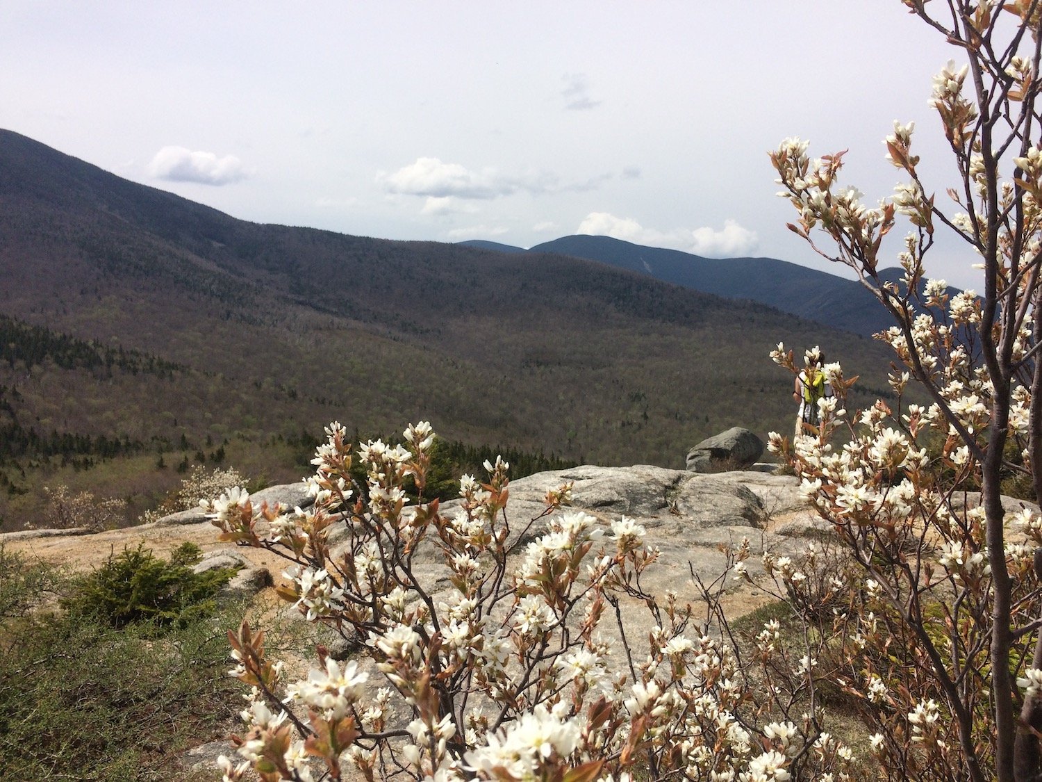
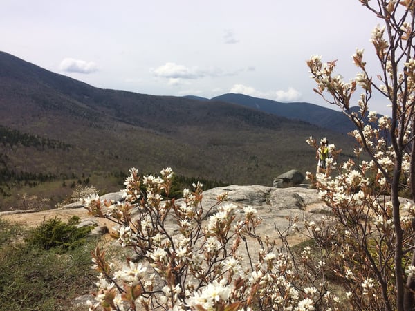
Artists Bluff
This is a short, steep climb to a spectacular viewpoint at the north end of Franconia Notch. There are very few trails in the White Mountains that offer a better reward for less effort than this. The trail starts almost opposite Echo Lake Beach, off exit 34C. Ducking into the woods, you climb steadily over rocky terrain. The trail quickly turns steep, heading up a gap in the mountain with cliffs on either side. At the top of the climb, there is a junction. Turn right for the bluff. The views of the notch are impressive. The ski trails to the south are Cannon Mountain, one of the oldest ski areas in North America. The huge mountain across the highway is Mount Lafayette, tallest in New Hampshire outside the Presidential Range. Take care on top. Though the top is spacious, the drop on two sides is straight down.
To get there: Take a right at the bottom of the hill onto Route 112 and follow to I-93. Turn onto I-93 North and follow until exit 34C. Take a left off the exit. The trailhead is a quarter mile up on the right, but parking may be prohibited on that side. You can either park on the opposite shoulder or pull into Echo Lake Beach State Park.
Difficulty: Moderate, short distance, steep climb*
Scenery: B+
Driving Time: 15 minutes
Distance: > 1 mile, round trip
Elevation Gain: 250 feet
**please use caution as the ledges on the upper part of Artists Bluff are very steep and can be slippery when wet or icy
Bald Mt.
This is another short, steep climb with a great reward. The trail begins less than a half-mile from the Artist’s Bluff trailhead, across from the base of Cannon Mt. Ski area. From the parking lot, the trail ascends to the left through mixed forest. Almost immediately, there is a junction with the loop trail. The main trail goes to the left. The right-hand trail leads to Artists Bluff and makes a loop possible between these two short, rugged peaks. The trail climbs and reaches another junction. Again, the right-hand junction climbs towards Artists Bluff. Take the left and you reach the summit of Bald Mt. There are some scrambles over rocks that are fun, but difficult. The summit offers amazing views of Cannon Mt. Ski Area and the surrounding valley, as well as Franconia Notch.
Difficulty: Moderate, short distance, steep climb*
Scenery: B+
Driving Time: 15 minutes
Distance: > 1 mile, round trip
Elevation Gain: 250 feet
*Please use caution as the ledges on the upper part of Bald Mountain are very steep and can be slippery when wet or icy
Mount Hedgehog via UNH Trail
This is an attractive loop path with three good viewpoints from ledges on and around the summit. To get there, take a left onto Route 112 and follow for about 20 miles. The trail starts from a parking lot on the right (south) side of the road, opposite Passaconaway Campground. In the parking lot, there are three trails. The UNH Trail to Mount Hedgehog goes to the left. The trail starts off easily, through very pleasant open woods. After the trail breaks off from the Downes Brook trail (not a pleasant or fun hike, I’ve done it), the loop junction is soon reached. Although you can go either way, most people go to the right.
The trail soon begins to ascend gradually with a few switchbacks. After a little more than a mile, you reach Allen’s Ledge. There’s a bit of a scramble and nice views, especially to the east. After the ledge, the trail climbs again gradually, reaching the summit at 1.9 miles. The summit is not completely open, but again, there are ledges with nice views. The large mountain directly south is Mount Passaconaway. Beyond the summit, the trail descends steeply, winding down to the right, and then turning left through more wide-open woods with occasional boulders and beautiful pine trees. About a mile from the summit, you reach the East Ledges. Though you’ve walked a mile from the summit at this point, it is actually very close to your left (but over 300 feet higher). There are tremendous views to the east again. The pointed summit in the distance is Mount Chocorua. From here, the trail descends gradually 2 miles back to the parking lot.
Difficulty: Moderate plus
Scenery: A-
Driving Time: 30 minutes
Distance: 5 miles, round trip
Elevation Gain: 1,250 feet
Mount Sugarloaf
The Sugarloafs are a moderate hike with great views for the effort. The trail starts in Twin Mountain. To get there, take a right onto Route 112 and follow until you reach the junction with I-93. Follow I-93 north to exit 35. Once you get off exit 35, follow Route 3 north to the junction with Route 302. From here, turn right (East) onto Route 302 and follow for 2.1 miles. Take the right onto Zealand Road (caution as this is a seasonal road and may not be open until mid-May). The trailhead is 1 mile up Zealand Road, on the right hand side. Park before the bridge over the Zealand River, walk across the bridge and the trail begins on your right.
The trail starts easily, following the Zealand River. It soon turns left, rising away from the bank, and crosses a logging road. The trail crosses a muddy section on some platforms and starts to climb gradually. There are some interesting massive boulders in this section. The trail begins to rise more steeply, ascending by switchbacks until a T-Junction is reached a little less than a mile in. The left route goes to Middle Sugarloaf, which is taller and slightly more difficult. The right-hand trail goes to North Sugarloaf.
Middle Sugarloaf
Turning left, the trail ascends through some nice pine trees and then into open woods. The trail becomes steeper and climbs some switchbacks as it nears the summit. There’s another large boulder and then a ladder just below the top. There’s some effort involved for a mountain of only 2,539’, but there are also really impressive views of the surrounding mountains and the vast Pemigewasset Wilderness.
North Sugarloaf
Taking the right-hand trail at the junction, the route to North Sugarloaf actually dips slightly and goes through open woods. It circles under the ledges of the north summit and then climbs more steeply through a nice pine forest. The trail circles around and comes out on top of the ledges of 2310’ North Sugarloaf. The views of Mt. Washington and the Presidential Range are some of my favorites.
Difficulty: Moderate
Scenery: B+
Driving Time: 30+ minutes
Distance: 2.8 miles for Middle only, 2.4 for North only, 3.4 for round trip for both
Elevation Gain: 900 feet for Middle only, 700 feet for North only, 1200 feet for both
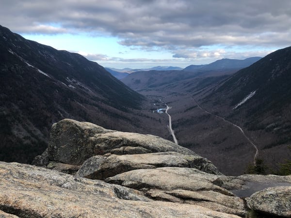
Mount Willard
This is a popular small mountain overlooking the Mount Washington Valley in Crawford Notch.
To get there, take a right onto Route 112, follow through town and turn right onto I-93 north. Follow until exit 35 and then head straight (north) on Route 3. Follow Route 3 all the way to the junction with Route 302, and then turn right (east). From here, it is 8.2 miles to the Crawford Notch Train Depot and Family Information Center. The trail begins across the train tracks from the parking lot (the tracks are live!). Look for a sign that reads, “Avalon Trail.”
A junction is soon reached. The Avalon Trail continues straight ahead to Mt. Tom and Mt. Field, two of New Hampshire’s four thousand footers. The Mt. Willard trail goes to the left. You soon cross a small stream in open woods, then turn right and begin to climb gradually. About a half-mile in, you pass by Centennial Pool, just below some cascades. Beyond here, the trail gets a little steeper, though it is never difficult. The footing is good, and you get a glimpse of Mounts Field and Tom through the trees. As you get higher, the forest changes to mostly pine trees, and the trail levels out below the summit. The trail ends at the summit, which is the top of a large cliff overlooking the valley, a thousand feet below. Views are tremendous, but please use great caution on the ledges, especially in wet weather or with youngsters.
Straight ahead, Route 302 snakes through the valley below you and on a good day, you can see almost to Maine. Mount Willey is the steep, rugged peak to your right, and Mount Webster to your left. These two mountains form the, “walls,” of Crawford Notch. Farther to your left, you can see Mount Washington through the trees.
Difficulty: Moderate
Scenery: A-
Driving Time: 30+ minutes
Distance: 3.4 miles, round trip
Elevation Gain: 900 feet
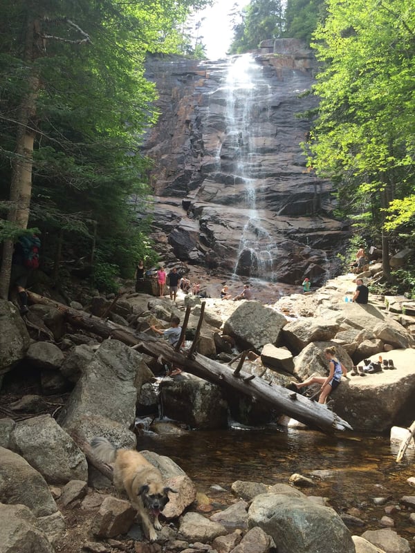 Arethusa Falls
This is perhaps the most impressive waterfall in New Hampshire. It’s a popular and relatively easy hike. To get there, take a right at the bottom of the hill, onto Route 112. Continue through town and turn right onto I-93 north at exit 32. Follow I-93 until exit 35, and then take Route 3 north (straight ahead). When you get to the junction with Route 302, turn right (east). From here, it is about 14.4 miles (or about 9.3 miles east of the Mount Washington Hotel). The parking lot is on your right, and there is ample room.
The trail crosses train tracks (live tracks). The trail climbs steadily through wide open woods. There is a spur path on the left, which goes to Bemis Brook. It offers a little more scenery, and it loops back to the main trail, but the second half of it is quite steep. The main trail continues ahead and gradually climbs away from the river to your left. The bank is steep and there are occasional views of local mountains through the trees. There are a couple of easy stream crossings and the trail drops sharply as it approaches the falls. The falls drop a majestic 150 feet before you, into a series of pools.
Difficulty: Easy to Moderate
Scenery: A-
Driving Time: 45 minutes
Distance: 2.6 miles, round trip
Elevation Gain: 750+ feet
Zealand Falls & Zealand Hut
Zealand Falls and Zealand Hut are a lengthy, but mostly easy walk to a beautiful set of falls and one of the Appalachian Mountain Club’s eight mountainside huts in the White Mountains. The trail starts in Twin Mountain. To get there, take a right onto Route 112 and follow until you reach the junction with I-93. Follow I-93 north to exit 35. Once you get off exit 35, follow Route 3 north to the junction with Route 302. From here, turn right (East) onto Route 302 and follow for 2.1 miles. Take the right onto Zealand Road (caution as this is a seasonal road and may not be open until mid-May). The trailhead is at the end of Zealand Road, about 3.5 miles in.
The Zealand Trail has a nice gradual start, through a beautiful mixed forest. You soon cross a couple of streams on bridges and pass through a muddy stretch. The trail gets closer to the main river and at 0.8 miles, there’s a short path to river’s edge. You soon cross the river on a wooden bridge. The climb continues to be gentle and you are soon rewarded with occasional views of the Mount Zealand and Zeacliff to your right.
At about 1.8 miles, the trail crosses through a swampy area, with a boardwalk laid across it. The views to the Zealand Range are excellent here. A half mile beyond this point, the AZ Trail leaves on the left, for Mounts Tom and Field, a couple of four thousand footers. The Zealand trail continues straight ahead, and after crossing the Zealand River on another bridge, reaches the shore of Zealand Pond on the right. At 2.5 miles, there is another junction. The Ethan Pond trail continues straight ahead into the wild and beautiful Zealand Notch, my favorite notch in the White Mountains. The hike into the notch is not difficult, but it’s over a mile further, in each direction, making for a long day.
To get to Zealand Falls and the Hut, turn right, up the Twinway trail. It’s only a quarter of a mile, but it does get steep here, hopping over large rocks. As you climb, you can hear the falls. When you reach the hut, at the top of your climb, there is a deck and a tremendous view out to Carrigain Notch in the distance. The large mountain on the right side of the notch is Mount Carrigain. The falls are on a short path to your left. Snacks and refreshments are available at the hut for a fee.
Difficulty: Easy to Moderate
Scenery: B
Driving Time: 35-45 minutes
Distance: 5.6 miles, round trip
Elevation Gain: 750+ feet
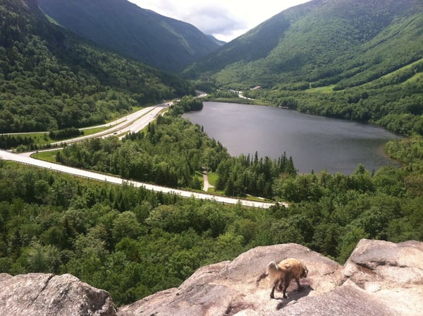
Lonesome Lake
This is a popular hike of moderate difficulty to an idyllic mountain lake nestled halfway up Cannon Mountain, with views of Mount Lafayette. The trail starts at Lafayette Place Campground, in Franconia Notch. To get there, take a right at the bottom of the hill onto Route 112. Turn onto I-93 north and follow until you reach Lafayette Campground in the heart of Franconia Notch, about 7.4 miles from exit 32. Note: If you are headed northbound, you must park on the right and walk under the highway. There is a tunnel between the two parking lots.
Once under the pass, turn left, cross a small bridge on the right and follow the signs for the Lonesome Lake Trail. It heads uphill through open woods, gradually at first. After crossing a small stream, the trail turns left and reaches a junction with the Hi Cannon Trail. This trail leaves to the right and climbs very steeply up to Cannon Mountain. The Lonesome Lake Trail starts to climb more steeply by switchbacks. As you approach the lake, the route becomes more gradual and actually descends a few feet. At the lake, there is a loop path. The left-hand route is slightly shorter, and goes over some logs that have been laid across muddy patches.
Lonesome Lake Hut is reached in a few hundred yards. In season, snacks and drinks are available for a fee, and there is a tremendous view across the notch to the Franconia Ridge.
Difficulty: Moderate
Scenery: B-
Driving Time: 15 minutes
Distance: 3.2 miles round trip, including loop around the lake
Elevation Gain: 950 feet
Difficult Hikes
Welch & Dickey Loop
Although neither mountain is tall, I included this (barely) in the difficult section. The whole loop is 4.5 miles, with a lot of open hiking on rocks and ledges. To get there, take a right onto Route 112, head through town and take I-93 SOUTH at exit 32. You’ll want to get off at exit 28 and take a left on to Route 49. Follow for 5.6 miles, then turn left onto Upper Mad River Road. After .6 mile, turn right onto Morris Rd. The parking lot is another .6 mile, on your right.
This is a loop hike, and I describe taking the right-hand trail, as it’s easier going up than down. The trail quickly crosses a stream and follows it through a hardwood forest for a half-mile. The trail starts to climb to the right, then angles back to the left and reaches some beautiful open ledges after 1.3 miles. There are often blueberries on these ledges in season. The climb is steady as you approach Welch Mountain and the views range from good to outstanding. There is one steep stretch just below the summit, a narrow cleft between two large rock, but it is not unmanageable. The summit of Welch Mt., 2605’, is reached at 1.9 miles. The views are excellent, especially over Waterville Valley.
The trail descends quickly from here, through a beautiful stretch of wildflowers, and back into the trees. There is then a steady ascent through pine trees to the summit of Mt. Dickey, at 2,734’. From here you can see down to Mt. Welch and the trail you’ve just taken, and there are more open views, especially up into Franconia Notch. The descent is gradual, though it’s over open ledges that provide more views and the possibility of more blueberries. The views gradually taper off as you descend back into the trees.
Difficulty: Moderately Difficult
Scenery: A
Driving Time: 30 minutes
Distance: 4.5 miles for the entire loop
Elevation Gain: 1,800 feet
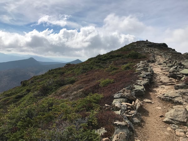
Mount Chocorua
Mount Chocorua is one of the most beautiful and popular hikes in the region, but it is challenging and should be attempted by experienced hikers, in good weather. The Champney Falls Trail is on Route 112, about 25 miles east of the resort (left at the bottom of the driveway), or about 1.2 miles beyond Bear Notch Road. The parking lot is on the right-hand side (south) and well signed.
The trail starts out by crossing Twin Brook. The crossing can be difficult but can be avoided by walking along 112 a very short distance, and then following the woods south. The trail reaches a junction with the Bolles trail on the right, then ascends very gradually through the woods. It climbs an embankment, away from the brook, enters some pinewoods, and dips slightly. At about 1.4 miles in, you reach another junction. A short loop goes to the left, and passes both Pitcher and Champney Falls. I have never visited them, but have been told they are lovely, especially in the spring and fall.
The main trail climbs to the right, and the loop junction is reached at 1.7 miles. There is a viewpoint to the north near here, and the trail starts to gain elevation, climbing through open woods. The trail climbs by a series of switchbacks, with occasional views to the north. At 3.2 miles, you reach the junction with Champney Falls cutoff. The cutoff heads left over the, “Sisters,” a ridge with three sub-peaks of Chocorua. The peaks are in the open and provide great views but add to the time and effort of the hike. The main trail continues ahead and passes beneath a rocky outcropping. Shortly before the summit, you reach the Piper Trail amid pine trees. After this, the trail breaks out into the open. From here on, the way is entirely treeless. If the weather is bad, you will be exposed to the full force of it. However, the view is breathtaking. Mount Chocorua is one of the most popular mountains in America, and this is why. To the south, you can see the lakes region, to the east is Maine, and to the north and west, the White Mountains rise in range after range. The tallest, to the north, is Mount Washington. The last quarter mile is all over open rock and involves one or two scrambles. Paint blazes on the rocks mark the way to the top, which is reached at 3.8 miles.
Difficulty: Difficult, strenuous
Scenery: A+
Driving Time: 30-40 minutes
Distance: 7.8 miles, round trip
Elevation Gain: 2,250 feet
Mount Lafayette
The 5,260-foot Mount Lafayette is the tallest mountain in New Hampshire outside of the Presidential Range, and 6th tallest overall. It is one of the most difficult hikes in the northeast, and the last mile is completely above treeline, and can be exposed to the worst of the weather. Climbers who reach the summit are rewarded with spectacular views of Franconia Notch, the Pemigewasset Wilderness, and Mount Washington in the distance.
Don’t let the relatively moderate distance of 4 miles each way fools you. Mount Lafayette has over 3500 feet of elevation gain and long stretches above treeline, making this a serious climb. The trail is located at Lafayette Place Campground. Right on Rt. 112 and then turn right onto I93 north. Follow about 7.4 miles to Lafayette Place, parking is on the right. The Old Bridle Path and Falling Waters trails leave from here.
From here, follow the Old Bridle Trail uphill and to the right. Within a couple of hundred yards, you reach a small brook. The Falling Waters Trail crosses this on a footbridge; the Old Bridle Path up Lafayette does not. The bridge crossing would lead you to Little Haystack and Mount Lincoln. The trail turns left, away from the brook, and climbs moderately at first, winding its way through an open Birch forest. About a mile in, the trail turns sharp right and runs almost level for a little while. It then approaches the edge of Walker Ravine, between Mounts Lincoln and Lafayette, and turns left again. From here on, the climb becomes more strenuous. After climbing steadily through the forest, you start to reach some ledges at the edge of the ravine. These ledges are good viewpoints, ideal to stop for a snack or a rest.
Beyond them, the strenuous climb continues and heads back into the woods over three hills called, “The Agonies.” These are the most difficult stretch of the trail and beyond them, there’s a bit of a letup. At 2.9 miles in, you reach Greenleaf Hut, and the end of the Old Bridle Path. The hut generally requires reservations, but day hikers can use the facilities or pay for a snack or drink of lemonade. The hut is located at 4,200 feet, and though it’s not above treeline, there are nice views up to the summit of Lafayette, still a mile away. There’s a small mountain lake, or tarn, just beyond and below the hut.
After a break at the hut, you begin the final mile long stretch to the summit, via the Greenleaf Trail. The trail dips and enters some pine trees and crosses a muddy stretch near the pond on some log bridges. From here, the trail begins to climb straight ahead through ever-shorter pine trees. The trail soon breaks out of the scrubby trees and into the open. From here on, you are above treeline, and in the fragile alpine zone. The views are outstanding, but if there is bad weather, you have no shelter. Storms can strike without warning here, so if the weather is deteriorating, it’s always wiser to retreat.
The trail ascends by switchbacks, turning right, approaching Walker Ravine, and then left underneath the summit cone. Near the summit, you pass underneath a huge boulder, before turning right one final time for the final push. The summit is reached at 4.0 miles. Views of the notch to the west, and the Pemigewasset Wilderness to the east, are unsurpassed.